Saturday, August 6, 2011 Norfolk to San Francisco
Get to the airport for the afternoon flight. Fly from Norfolk to Las Vegas, Lost Wages to San Diego, and San Diego to San Francisco. Bunch of drunks on the plane from Vegas to San Diego. Took the opportunity to finish Ecology of a Cracker Childhood and started Gods and Generals. Flight was long, ate crap food to save money, but the flight attendants on Southwest were generous with the snacks and drinks, and with the humor.
Happy to get in at San Francisco even though the flight arrived late. Caught the shuttle to the hotel, Millwood Inn, and hit the hay.
Sunday, August 7, 2011: San Francisco to Yosemite National Park
Got up early, showered, checked email and sent messages on the hotel computer, and got my free breakfast on. JC had mapped out the travel path to get to Rent-a-Wreck (RAW) from out hotel. We caught the bus to the Bart, took another bus to within about 3 blocks of RAW and hoofed it there by about 9:15 am.
Picked up our sporty Kia Rio and, with the assist of JC’s smartphone GPS app, made our way back to the hotel in no time flat. Picked up all our luggage and camping gear and hit the road. Made one pitstop to the closest REI store only to find they were having their end of the season clearance sale = MOBBED! At least the mob was outside. We went int he store and got our MSR Superfuel and JC picked up a pair of sturdy trekking poles.
Now we were on our way to Yosemite for real. The driving was easy and we made a few stops to take some pictures, buy almonds, eat some lunch, and enjoyed the ride. We made it to the gates of Yosemite in about 5 hours - right on time. Normally, the entrance fee is $20 and it’s good for 7 days. As luck would have it, our itinerary would have us re-entering the park after 8 days and we risked having to pay the entrance fee twice. After explaining our predicament, seeing our backpacks in the back seat, noticing the sheer economy of our ride, the uber-cool Park Service guy let us slide on the entrance fee. Sweet!
We get our camp site at Crane Flat (#222) - very nice.

Good site and it backs up to a beautiful meadow.

We set up two tents to delay the impending backcountry 2-man tent “bro-mance” (as my wife likes to say while chuckling!). Then we head down into the valley to get JC some face time with the granite. The Valley does not disappoint. As the sun starts to fade, the Range of Light blossoms in all its glory. I cannot resist taking more pictures of the landmarks - El Cap, Half Dome, The Three Sisters, ++++++++ We have a beer from he Curry Village store before heading back to the campsite for some dinner in the dark.
The Valley as the sun sets...

Monday, August 8, 2011: Yosemite National Park
Up at 6 am and get busy making breakfast - oatmeal and coffee. Clean up, get water, messed around a little, and left by 7:30 to head down into the Valley. We planned to hike the Panorama Trail down from Glacier Point to get some altitude in our lungs and miles on out shoes. Just daypacks on this hike.
Drove to the Yosemite Lodge to pick up the Glacier Point Tours (209-372-4386) bus tickets to ride up to Glacier Point. Caught the bus at 8:30 am. Jack, our driver, was great and full of facts and stories to entertain us as we climbed the road to Glacier Point. Jack told us about the "Avalanche" fire that was burning in the park and was being watched but allowed to burn to provide all the natural burn benefits to the forest ecology. At times were were surrounded by the thick heavy smoke and it lingered int he valley and up in the high peaks, depending on the wind direction, for part of each day were were around the Yosemite Valley. On the way up to Glacier Point, we saw two of the three wildlife stars of Yosemite (mule deer, coyote, black bear). First we saw mule deer which were common on our trip. Then we saw a black bear mother and her two cubs. It's hard to not get excited at seeing bears!
Got to Glacier Point, showed JC the sights, hit the loo, and then started the Panorama Trail. Took lots of pictures of Half Dome as we hiked to Illoette Falls.
Half Dome from the Glacier Point Geology Cabin

JC doing his best North Face imitation...

Upper and Lower Yosemite Falls as seen from from Glacier Point

The start of the Panorama Trail


More Half Dome...

About only a mile down, we ran into a guy who had rolled his ankle and was headed back up to see if he could cajole the bus driver into carrying him back down to the Valley. Talk about getting spooked! I was being careful not to end out adventure before it started.
Looking at the back side of Half Dome as we hike along...

Illilouette Falls was pretty and flowing good! Here it is with the back side of Half Dome in the background.

Old sterioscopic view of Illilouette Falls...

We stopped for lunch upstream of the falls and took our time to soak in the forest gestalt before continuing on to Nevada Falls.
JC pumping water...

The stream above Illilouette Falls where we had lunch...

The oft ignored sign warning unwary adventurers that the falls present a danger...

The cascade leading to the placid pool before the stream disappears over the edge of Illilouette Falls....

Along the way, we see lots of squirrels and chipmunks, and some funky grouse - mother and chick.

The trail continued to provide stunning views of the backside of Half Dome and Liberty Cap (featured here)

A unique handcrafted water control structure along the trail...

Views of the forest on the way to Nevada Falls...


Nevada Falls was big, raging, and crowded. There were people all over resting, soaking their feet (we did too), pumping water, and generally hanging out in the stream and pool above the falls.
The stream leading to the brink of Nevada Falls...

Nevada Falls with a veil of smoke from the Avalanche Fire...

The way down from Nevada Falls was a steep, sheer, set of stairs. It was slow, crowded, and hard going. But it did provide spectacular views of Nevada Falls from below. See for yourself!

The cascades below Nevada Falls....

Once the grade started to level out, we stopped at Silver chute, then Emerald Pool, and then to Vernal Falls. Incredibly, with the over-the-falls deaths of 3 scofflaws a couple weeks prior, there were still people beyond the warning signs and in the pool above the falls. Darwin at work!!!!!
Took some snaps of Vernal and then made our way down more steep steps to get down. Having hiked the Mist trail twice now, I don’t have any desire to ever do that again! I’m over those crowded steep steps! Once we were at the bottom of the trail in Happy Isles, JC called his wife and I went to the Mountaineering Shop in Curry Village to look around. JC meets up with me and we get beers and chips and hang our on the porch before driving home for some Mountain House meals and bed.
Sunset over the valley...


Tuesday, August 9, 2011: Yosemite (Tuolumne Meadows) to Mammoth
Got up early - 6 am - and had just a Clif bar and coffee (anticipating a big breakfast at the White Wolf Lodge. JC wanted to see some Sequoias while in Yosemite, but we didn’t have time to commit to go all the way to the Mariposa Grove so we checked out the Tuolumne Grove instead. It was a mile downhill to get to s small grove of trees arranged along a short loop. If you wanted to see sequoias and check the box, you could do it here, but it was poor in comparison to Mariposa. If you really want to see the BIG trees, make the time to go to the Mariposa Grove.
JC checking out the Sequoia's core...

We (I) huff and puff the mile uphill and make it to the White Wolf Lodge at 10:30, only to find that they stop serving breakfast at 10 am. Damn! We drive on to the Tuolumne Meadows with stops at Olmstead Point and Tenaya Lake for pictures. We tried to pick up our backcountry permit a day early, but got shut down.
Tenaya Lake...


Rocks? Oh, I see one!

We hiked to Soda Springs (naturally carbonated mineral water) and the Parsons Lodge. The Lodge was built in 1915 from local granite and was originally a meeting room for the Sierra Club. We then continued on towards Mono Lake and Mammoth.
Soda Springs...

Cathedral peak with the Tuolumne River in the foreground...

On the way out of Yosemite, you’re supposed to show your entry fee receipt (to catch anyone who snuck in at night and didn’t pay). That ranger who let us in for free probably knew we’d get tagged on the back end and all the while we thought he was cool. Once at the booth, we just acted stupid, rummaged around for our immaginary receipt and then the ranger asked us how much we paid at the entrance. We knew the answer to that question, 20 bucks, and she let us pass.
Once out of the National Park, we passed some nice and some sketchy campsites before winding our way through Tioga Pass. We pulled the Kia to the right on all the climbs and let others pass as she struggled to make the grade. Don’t hate the Koreans, she was a good little, fuel-efficient girl!
Tioga Lake...

Tioga Pass...

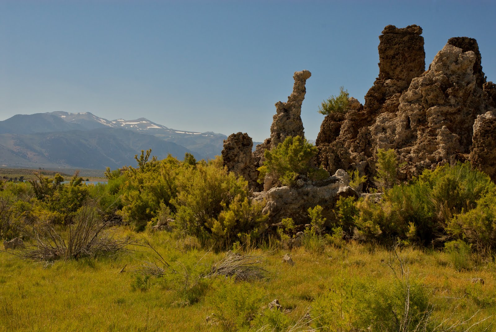
We came upon Mono Lake and made a diversion to see the Tufas (mineral formations exposed in the lake due to a draw-down of water by the City of Los Angles). At one of the overlooks, we spotted this cool cat with an Area 57 sticker on his VW camper. Off the grid?

We made a stop at the Mono Basin Visitor Center in Lee Vining and got directions to the must-see South Tufa formations.

Mono Lake was dry, barren looking, and JC said it looked lifeless. Except of course for the 10 gazillion little black flies that rimmed the lake shore. Thank god they didn’t attack or bite! We got some pictures of the Tufi (plural?) and then continued on our quest.
Tufi...


Remembering my Tidewater Appalachian Trail Club roots, we stopped at the Mono Cone for some ice cream.

Tooled into Mammoth and stopped at the Mammoth Visitor Center (worth a stop), picked up a Centennial Devil’s Postpile pin, and then headed on to Shady Oaks campground. After checking in, we took the drive up to the Mammoth Ski Lodge to recon where we would stage the car and pick up the YARTS (Yosemite Area Rapid Transit) bus back to Tuolumne. Got that squared away, and then headed back down into town for some pizza, beer, and last minute map checks and camera battery charging at Joh’s Pizza using their wall outlet. That’s one thing that sucks about Yosemite campgrounds - unlike Yellowstone, the Smokies, or others I’ve been to, the bathrooms don’t have power outlets to recharge camera batteries so you got to carry extras and get creative with recharging. I think I’m going to get a solar powered charger so I don’t have to worry about this in the future.
Back to Shady Oaks, for a pack shakedwon. We set up the tent, I retrieve my other (Nikon) battery charger from the camp host’s RV outlet, hit the head, and go to bed.
Wednesday, August 10, 2011: Mammoth Lakes back to Tuolumne Meadows (Yosemite NP)
Got up at 5:45, broke camp, reloaded the pack with everything I would need for the JMT, and headed into Mammoth Lakes to get coffee and a muffin before heading on to the Mammoth Mountain Inn to pick up the YARTS bus back to Tuolumne Meadows.
JC and our pre-packed "yard sales"...

Parked the car and hopped on the bus with two other backpackers. I hung out at the Tuolumne Campground Office while JC went to get the Backcountry permit. Once secured, we walked back into the campgrounds and found the back loop where the backpackers campground was located. We paid our $5 per person at the self-serve kiosk and set up the Big Agnes 2-person tent. With time on our hands, we headed to the camp store. I got a Pepsi (no Coke!) to try to soothe the raging headache I had. (I assumed the headache was from caffine withdrawl, but would later find this was a symptom of my worsening altitude sickness)
The Pepsi gave no relief, but we decided to hike ~4 miles RT to Dog Lake (from the Glen Alum Trailhead) to get more miles and altitude under out belts. We also wanted to see how bad the mosquitos were - since it was a big topic of conversation at the backcountry permit office.
On the way to Dog Lake (520’ up), I stopped to fish in the Tuolumne River. I got hits on the hopper pattern I had left over from a previous trip to Yellowstone, but I lost it somehow due to a hastily tied knot. My bad. I tried a stimulator in the same seam and at a few other places, but it garnered no interest. I think it was too big!

On to Dog Lake. We hiked through the Tuolumne meadows, saw herds of mule deer and stalking tourists, trout in the streams, a bear cub by the road, a snake and a marmot among the rocks. When we got to Dog Lake (9,170’), we found that it was very beautiful, but there were lots of mosquitos that would attack as soon as you stopped walking. After a liberal application of DEET, JC and I hiked to the far end of the lake looking for the inlet stream. We found a broad meadow a little channel cut in the peet that we guessed was the inlet. Very beautiful place with lots of lovely flowers surrounding the lake. Well worth the hike.
Dog Lake (One of my favorite images from the trip)

Dog Lake, shoreline flowers...

After the hike down, I check out a hotspot and find a nice big blister on the side of my big toe. After some mandatory liquid sedation of the operating attendent, JC lanced the blister, cleaned it and applied moleskin and taped it in place. Feels good. We ate dinner and had lots of conversations with our camp mates. My head was still aching when I went to bed.
Thursday, August 11, 2011 Tuolumne Meadows to the Lyell Fork Bridge
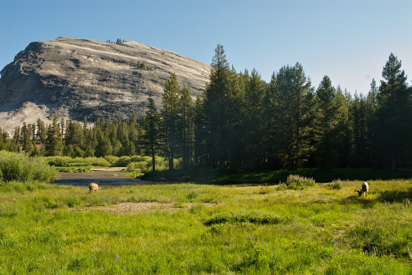
We got up at 6 am, gave away our extra food, and were out of camp by 8:00 am. We messed around a bit, taking pictures of mule deer in the morning mist (elevation ~ 8585').
Mule deer in the shadow of Lembert Dome (a roche moutonee - formed by a glacier flowing up and over the granite top.)
Finally connected with the JMT by about 9:00 am.

The hike eastward up Lyell Canyon was filled with gorgeous scenery! If you lived close by and could get a wilderness permit. this would be a great place to set up a base amp and hang our for a couple days dayhiking and trout fishing! As we passed, the prairie dogs chirped at us to warn their kin and we saw marmots scurry among the rocks.

The beautiful Lyell Fork of the Tuolumne River...


At 11:30, we passed the avalanche rock slide that marked the halfway point or day’s hike and the place where you can legally start camping along the trail. We stopped and had lunch and I fished a bit.


Caught one brookie on a royal coachman “X” pattern.

There were spectacular views of the Lyell Fork of the Tuolumne River and the canyon on either side.


We made it to the head of the canyon by 1:30-2:00 pm (9000') and began the 1 mile climb up ~ 700 feet in elevation. For me, the hike up was brutal! I was stopping every 100 paces to rest and catch my breath. My headache had not abated and I did not know, but my altitude sickness was about to add nausea to it's little bag of torments.
Here, Bruce from Scotland powers past us...

Trail maintenance....

JC and I made it to the Lyell Forks Bridge (9650') at around 3:30 pm. I was exhausted, but we set up the tent and napped as mosquitos hovered looking for a way into the mesh. Got up around 5:30, washed sweat-soaked clothes, gathered firewood, and made dinner. On top of the headaches that had accompanied me up the trail, I now was nauseous too. A cup of tea (caffine) did not help with the headaches (I did not recognize the common symptoms of altitude sickness). After dinner, I made a big fire and burned the food I couldn’t bear to eat. We got the bear canisters set up, but started to worry what to do with the packs since the Lyell Forks Bridge campsite is notorious for bear raids. In the end, we left them outside, but a little ways from the tent. The mosquitos tapered off after sunset, There was a nice big moon. It didn’t take long for the roar of the river rushing in the gorge below us to put us to sleep.
Friday, August 12, 2011 Lyell Forks Bridge to Thousand Island Lake
Got up at 6 am and pumped water for breakfast. I was still feeling sick to my stomach and could only eat 1/4 of my oatmeal and take a few sips of coffee. We broke camp and hit the trail at 8:30 to begin the climb to Donahue Pass. On the way up, we encounter pockets of snow. Aside from the nausea, it feels good to be high up and in the snow zone.
In the snow zone...

We climbed about 500' in elevation to a small lake surrounded by a meadow. It was great to see snow in the mountains, but the pass was out of view and the added elevation was daunting.

There was a red tinge to the snow and we were trying to figure out what that was from. My best guess was that the pollen from the surrounding pines was tainting the white snow (like the yellow pollen that covers everything back home in VA).
Here's a picture of a possible culprit...

A view of the lake from above...

We rock hopped across the lake outlet and continued to climb along a narrow trial and crossed a bunch of snow-melt streams and we went. Every now and then we had to cross a patch of snow and we were careful not to slip and were hoping not to punch a hole through a gap in the rocks underneath. We encountered another lake and again had to rock hop across the outlet. I wedged a trekking pole between two rocks and when it didn't release, I got thrown off balance and had to take a big dunking step in the water to keep from going all in. I rallied and got to the other side. We took a break so that I could change socks and I'm very glad we did.
Here's the lake that almost dunked me with more red-tinged snow....

Up we climb, with spectacular views all around.
Flowers flanked both sides of the trail...

Engineered steps led the way...

Crystal clear puddles were an amazement...

I was slow going as we picked our way up the grade. There were tricky rock sections interspersed with snow patches, but finally the pass came into view. We had a long stretch of snow to traverse as we climbed and so we followed the path of those who came before us. I know seeing the top of the pass buoyed my spirits. JC said the views made him want to yell “Ricola”.
Snow field traverse....


Reaching for the top of Donahue Pass...

We had our lunch at Donahue Pass (11,056') which is the Yosemite border. A marmot chirped at us, the intruders, as we enjoyed the view. Before long, we began to pick our way down and into the Ansel Adams Wilderness (formerly Minarets Wilderness) and the Inyo National Forest. As we wove our way down the switchbacks, the scenery was filled with glacial erratics - boulders dumped by one of the glaciers.
Looking down into the Rush Creek drainage from Donahue Pass...

The Rush Creek drainage (9,640’) at the base of Donahue Pass was very pretty, but also full of mosquitos so the bug nets came out and we raised and unfurled them as the need arose. Rush Creek drains to Mono Lake, the end of the line since Mono has no outlet.


The quiet stretches of Rush Creek looked like this...

Everywhere you turned, the scenery was spectacular! Here we are looking at Koip Crest to the north...

Among the mountains, snow, and clouds! Banner Peak points the way to the heavens...

JC crossing the Rush Creek log bridge at 10,040' near the junction of the Marie Lakes Trail...

Rush Creek picking up speed as the elevation drops...

We made it to the base of Island Pass by 3 pm, pumped water, and had a snack to fuel up for the 600’ climb.

The pitch to Island Pass was not as steep as Donahue and there were good switchbacks, but I became exhausted nevertheless. The nausea and lack of food in my stomach were taking their toll but we continued on - taking comfort in all the beautiful scenery.
A fallen tree on the way to Island Pass. Koip Crest in the background....

The twisted remains - nearly as beautiful in decay as in life...

The top of Island Pass (10,205’) and the surrounding plateau of land was gorgeous - one of the prettiest sights on the hike. In retrospect, if we could have extended our trip and planned to camp at Island Pass, we would’ve.


The way down from Island Pass was full of little crystal clear ponds and panoramas filled with the looming Banner Peak. Since we were on the west side of the crest, all the water we would see for the rest of the trip would drain into the San Joaquin River and eventually flow into San Francisco Bay. The backdrop on our horizon was now the Ritter Range with Banner Peak most prominent.
I was thankful when we made our way 1.8 miles down to Thousand Island Lake (9,833’).

Unfortunately, it was a big pain to try to find a campsite meeting the rules (not on vegetation) as the rocky perches away from the lake or feeder streams were few and far between. I was exhausted so JC did all of the work hunting for a site and he finally found a spot to share with Bruce from Scotland - a guy who passed us on the way up to Donahue Pass. Bruce was on the trail to do the full JMT, but was suffering from altitude sickness like me and he was saying if it did not clear up in a day or two he was going to abandon his attempt. I could totally understand. You can’t do that trip without eating to refuel the furnace!
We made dinner, and, once again I could only eat about half of my raimin, We cleaned up our bowls. To keep my mind busy, I fished for a while and lost a fish on the retrieve. Probably not a good hookset on the little guy. There were lots of “gulpers” taking tiny little black gnats - size 20 or 22 - a fly I did not have.
Took some sunset pictures and went to bed. I hate to say it, but I was thinking: half done.
Electric sunset at Thousand Island Lake with Banner Peak front and center!


Saturday, August 13, 2011 Thousand Island Lake (TIL) to Rosalie Lake
Woke up early and pumped water. Fished a little and took pictures while JC slept. Hooked another small fish on a size 16 Henryville Special (smallest fly I had), but lost him.
Sunrise with rising trout disturbing the mirror effect of Thousand Island Lake...

There seemed to be a lot of non-backpackers at TIL. There were lots of base-camp type set ups, tons of people fishing the lake, dogs, etc. Seemed obvious we were not in the National Park and it did not feel much like backcountry. We would have much preferred to stay someplace more remote like Island Pass or pressed on to one of the other lakes if I had the stamina.
Boiled water for breakfast, but 1/2 of a Clif bar is all I could get down. Didn’t fight the sickness at this point, just went with the flow. We broke camp, used the head, and got on the trail a little late. It was 9:45 when we rolled out of TIL.
On our way again...

We had to hike up and out of TIL and then down again to make the 2.6 miles to Garnet Lake (9,678’). It seemed to take longer than it should’ve. That’s probably just me feeling weak. Poor JC having to put up with my crap!
Ruby Lake was clear, beautiful, and trouty...

Garnet Lake looked like a repeat of Thousand Island Lake...

Crossing the outlet of Garnet Lake and continuing on....

After another 2.5 miles, we have lunch at Shadow Creek (9,000’) where I force down the second 1/2 of my Clif bar. We continue another 0.9 miles down to Shadow Lake (8,737’) and then turn southeast to start the last steep climb of the trip (yeah!). Take it slow, again about 100 paces at a time.
Flowering shrubs and ground covers are our reward for making it to the top of the pitch...

The landscape is filled with talus...

On the descent we pass a guide and his client on horseback heading to Garnet Lake for some fishing...

We descend 1,100 feet past a small meadow and through a tiny canyon with lodgepole pines and mountain hemlock cover. Anywhere we find water, flowers abound.

At 9,000' we came to a trail junction - right went to Ediza Lake - but we continued on to the left towards Shadow Lake. Along the way, we paralleled and crossed Shadow Creek.
Amazing crystal clear water with to-the-bottom visibility and interesting fringing wetlands...


Shadow Creek becomes a torrent...

Shadow Lake...

After an hour and 15 minutes, we make it to Rosalie Lake. It lives up to its reputation. Gorgeous!

We find a nice camp site with a good fire pit nearby. We take pictures, set up the tent, wash clothes and chat with neighbors. During the conversation, we find out that the highly anticipated showers at Reds Meadow are our of service and will be for the entire year! WTF!!!!! That’s a stop I think that most backpackers covet! Our heads swim with alternative plans for a scrub. I am still planning for a stop to fill my belly with one of their famed milk shakes (down at lower altitude)!
After dumping the packs, setting up camp, and squaring away the bear canisters, we climb some rocks to see the sunset.
JC contemplating the meaning....

Looking towards Mammoth Mountain...

JC and I return to camp for a dinner of couscous and Kathi’s special spices - Yum! I eat as much as my stomach will allow. After dinner, JC stacks the bear canisters to see if they get knocked over by a bear.
We make a good campfire and I repeat my new ritual of burning uneaten food. We stare at the flames fro a while, spread out the coals in the pit, and then hit the hay.
Sunday, August 14, 2011: Rosalie Lake to Devil's Postpile National Monument

I’m up first, and I check the clothesline to see if the clothes have dried overnight. Even though the temperature drops down into the 40s, the air is so dry the clothes are dry after being washed late the night before. I snap a few pictures of Rosalie Lake as the sun comes up and then go to get JC so we can get moving towards that end-of-the-trail milkshake at Red’s Meadow.
Gladys Lake with the pinnacle of the "Two Teats" in the background...

One of the many Trinity Lakes.....

We’re dropping down through the trees. The JMT guidebook says the soil in this region is volcanic, but it’s hard to tell the difference - it’s just all dusty. JC continues to be accosted by mosquitos but it’s not so bad for me - my stink must be off-putting! Once again, water is life. Where ever we cross a snow melt stream, we're treated to flowers, flowers, flowers.

The trail down from Trinity Lakes...


It seems like we’re moving fast enough, but the trail miles yield slowly. We’re running into a bunch of folks heading in the other direction and we swap stories about mosquitos and altitude sickness. We drop down to Jonhston Lake and the surrounding meadows (8,120’) and enter the Devil’s Postpile National Monument.
As you cross the Middle Fork of the San Joaquin River into the Postpile, you are immediately greeted with a basaltic extrusion (derscribed as warped organ pipes)veering off to the right - cool!
The San Joaquin...

Extruded basalt marks the entrance to the Devil's Postpile National Monument...

Instead of heading left to the Ranger Station, we continue on with full packs to take a look at the main postpile attraction - accordianlike columns of blue-grey basalt that formed 10,000 years ago when magma flowed through Mammoth Pass and fracturedd vertically. We also hike to the top of the formation to look at the hexagonal honeycombed extrusion patterns.
The Devil's Postpile...

The hexagonal pattern of the extruded volcanic magma. I love to say that word like Dr. Evil from the Austin Powers movie - magma!


OK, I’m done climbing! We head to the ranger station and wait for the bus to Red’s Meadow Resort. We get a free ride to the Resort and meet up with two guys we met at the entrance to the Postpile. They met online and were hiking the whole JMT. At the Red’s Meadow grill, they struggled to get a double cheeseburger down while I opted to fill my belly with some comfort food - a big chocolate shake. It’s old school - in a big metal shake cannister, and topped with whip cream and chocolate sauce. Come to Papa! It was worth every penny of it’s exorbitant cost!
JC points to the finish line at Red's Meadow Resort...

The resort store... backpacker prejudice???????

We hop back on the shuttle bus, and pay $7 this time, to make our way back to the Mammoth Mountain Inn. We are happy to find that the Kia has not been attacked by a bear or vandalized in any other way. We dump our stuff, grab our toiletries, and head back to the Mammoth Mountain Inn where we’ve been told we can pay for a shower. We’re directed through a maze of backdoors, parking garages, and service elevators (keeping us hidden from the true guests) to a bathroom with a single shower adjacent to the hot tubs and a small outdoor pool. JC and I get clean just before a long line forms.
Feeling refreshed, we go back to the funky coffee shop in Mammoth where JC gets a killer sandwich, but I hold off for a burger back at the Tuolumne Grill. We head back to Yosemite with a quick stop at the Mono Basin Visitor Center for gifts for my kids. The Kia climbs slowly through Tioga Pass and shortly enough we’re back in Yosemite and Tuolumne.
We pull up to the Tuolumne Grill to find it closed. Damn it! JC is making comments about his great sandwich as I gnosh on microwave mac and cheese and some chips and dip that JC gets as a snack. We drive up to backpackers campground with the car this time, unload our gear needed for the night, set up camp, and then go park the car in the Lembert’s Dome parking lot overnight. Walk back to the backpacker’s campground and enjoy a nice campfire program by one of the seasonal Rangers. The crowd shares impressions and what’s special about Yosemite. Good classic campfire experience!

We’re back in two tents again - the bro-mance is over!
Monday, August 15, 2011 Tuolumne Meadows to San Francisco
We get up, break camp, walk to get the Kia (no bear invasions), drive it back to the backpacker’s Camp and load up. We head to the wilderness permit office and donate our remaining Superfuel (half a can) to a very grateful park employee and score some extra Yosemite Wilderness stickers in the process. In the parking lot we meet a trio of NC belles and donate our two mosquito head nets to their cause. They are slightly red-eyed from an overnight drive and perhaps a little underprepared but stoked nonetheless.
We start the drive home with a leisurely stop at the White Wolf Lodge grill for an all-you-can-eat breakfast that erases most of the weight losses we may have managed on the trail.
White Wolf Lodge...

On the way back through Tuolumne, we are ever mindful of our speed as these signs remind us that...

Thankfully, this sign has not date scrawled across it. Putting a date on the sign means that a bear has been killed in a collision.
We stop at the store at Crane Flat for some Devil’s Postpile brew and a few more trinkets. I make a pitstop at a turnout outside Yosemite to collect a few massive sugar pine cones. We make another stop near Groveland so JC can pick up some tie dye for his Mom (we pass on the homemade elk jerky).

We stop for lunch in Oakdale (again JC gets the gourmet sandwich while opt for the dollar menu), and we make it back to San Francisco in the early afternoon. We touch base with my friends Tom and Leslie and make plans to meet for dinner in Chinatown. Next mission - get JC’s feet wet in the Pacific Ocean!
We get downtown, but get totally hosed on Market Street because we can’t make a left hand turn to head toward the ocean. Out attempts to drive through Golden Gate PArk are thwarted, but we do manage to catch a glimpse of Haight-Ashbury and skirt the northern edge of the park until we make it to Ocean Beach. JC gets his feet dipping box checked and we start heading south on Highway 1.
Pacific foot massage...

We make a quick stop at Fort Funston to see the cliffs and Pacific Ocean and are mesmerized by the hang gliding going on there. Beautiful!
The beautiful CA coast looking south from Fort Funston...

Looking north from Fort Funston...

JC enjoying the gliders...

We make our way back to the Millwood Inn in beautiful downtown Millbrae. Chaos ensues as we unpack everything and begin repacking for the flight home. We wash out fuel canisters, charge camera batteries and phones, repack flight essentials (Ipod, reading material, snacks, etc). We shower and put on our best (least stinky) old clothes and drive to the BART station to catch a train into SF to meet the Crabs in Chinatown. There is some “civil unrest” at one of the BART stations (protest about the jamming of cell phone signals so people couldn’t photograph alleged police brutality) so there are armed cops, dogs, and riot gear all over the place.
We make our way by foot to the China Gates and window shop as we go. We pick up a few more gifts and then meet up with Tom and Leslie. Greetings and hugs all around with loud banter we pick a restaurant - one that has dim sum for JC. We chose one at random and the food is excellent! We have a great time and Tome and Leslie give us a ride to the BART station. We make it back to the Millwood Inn and the repacking resumes. I stay up until 2 am doing work for Lynnhaven River Now until they kick me off the hotel computer. Bed!
Tuesday, August 16, 2011 Sand Francisco, CA to Norfolk, VA
We drive to Rent-A-Wreck, drop off the KIA (no harm no foul!), and get a ride from the RAW crew back to the BART station for a train ride to the airport. Catch the plane to Las Vegas, hang for a couple hours, and then make our way back to Norfolk. JC reads the Ecology of a Cracker Childhood book cover to cover while I knock off sections of Gods and Generals. We make it home after midnight. JC picks up a car dropped by his wife and my friend JD picks me up for the ride home.
Glad to me home, safe, and with another great adventure under my belt!
No comments:
Post a Comment