Sunday, September 15, 2019

Seattle In A Morning...


Tuesday - Seattle

Even though I was dog tired, I still rose at 6 am, made a double espresso, repacked and organized my gear for the fishing leg of my trip, and played with Luna as Jen's son watched cartoons.  Jen and I walked Luna to a lakefront park where Luna chased the tennis ball and swam mightily.

After our morning chores, we scooped up Jen's son and she took me into downtown Seattle for a whirlwind tour.  We walked along Pike's Market and looked at the famous fish-tossing market.
We walked past the site of the very first Starbucks.  We walked along the waterfront, saw the ferris wheel and took in a virtual reality show - Flights Over Seattle.  Jen also took me to the famous Gum Wall.
Fascinating and gross all at the same time.

Lastly, we climbed up to Kerry Park for a view of the City, the Space Needle, and Mount Ranier lording over it all in the background.  Not too shabby.
Back home, we ate sandwiches, I finalized packing, and Jen took me to the airport for the flight to Vancouver, through customs, and then on to Comox on Vancouver Island.

I arrived at the small Comox airport and found my friend Kelly outside for the 30 minute ride to Campbell River.  I reunited with Sheridan, his wife, and made the acquaintance with their two dogs Watson and young Raven.  I was also introduced to Kelly and Sheridan's friends Ken and Cynthia.  We talked some, watched some carpool karaoke and then hit the hay for the early morning water taxi departure for the Phillips Arm and our volunteer work with the Gillard Pass Fisheries Association. 

(The saga continues on www.sweeetandsalt.bolgspot.com)


Monday, September 9, 2019

Olympic National Park - Hurricane Ridege Loop Trails

Monday- Hurricane Ridge

My humble little campsite...

I followed the same pattern - rose at 6, changed clothes, brushed teeth, but this time I packed the tent (but left the fly and footprint in the backseat to dry, and threw everything in the car and headed to Port Angeles for breakfast.  

On the way, I drove along Lake Crescent as the sun was rising and was treated to this beautiful scene.
In just moments, the sun was high enough to illuminate the eastern end of the lake.
According to the signage, "this fiord-like terrain with steep rock walls and a long narrow lake was carved by a glacier.  As the glacier receded, it left the lake whose 600' depth demonstrates the strength of the glacier's gouge.


I found a little coffee bar and got a large light and sweet with a toasted bagel.  I stopped at the Olympic NP welcome center for intel and then proceeded up Hurricane Ridge Road. The entrance road to Hurricane Ridge was long, steep and winding, but the slow climb was perfect for taking in the mountain views.  

I parked the car at the Hurricane Ridge Ranger Station...
 ...and was awestruck by the glacial views that we so easily accessible.  

 Here's how you can ID all the peaks!
The panorama...
  Most of the Ranger Station wasn’t open yet, so I started out on the Cirque Rim Trail.  The Mountain View’s were nice but not spectacular.  
 The round peak is Hurricane Hill.  The two little spikes are Unicorn Peak and Unicorn Horn with Griff Peak to their right.  Lost in the haze is Vancouver Island, the Straight of Juan de Fuca, Victoria, San Juan Island, and the British Columbia Coast Range.

Another view with some cool framing.

I took some photos of a doe and her fawns and then made my way up to Sunset Ridge for sweeping views of the alpine scenery.  
I climbed up to Sunrise Ridge for some sweeping views - here looking west.
In B&W...
 A panoramic shot...
I took a picture of a couple from Brevard County in NC and we talked for a while about Kathi and I retiring there.  As I bid my future neighbors farewell, I continued on the High Ridge Loop Trail that circled me back to views of the Lilian and Elwa River valleys ...
 ... and the Olympic Range came back into view.
 The snow towards the center of the frame is the Blue Glacier with Mt. Olympus (7,960') to the right (I think!) and then Mt. Carrie (6,995') to the right of that.

I couldn't get enough of these views!
 In B&W...


I made my way back to the Ranger Station and soaked up the info inside.  Check it out!
Did you know that the first documented ascent of Mount Olympus was made by three members of the O'Neil Expedition in 1890?  For reference, Washington only became a state in 1889 and the Olympic Peninsula was a mysterious and forbidding wilderness.  In 1907 the Mountaineers, a Seattle hiking club organized an expedition to climb the East Peak, Middle Peak and West Peak (the tallest).  The party that reached the West Peak included Anna Hubert, the first woman to climb Mt. Olympus.

Here's a cool topo rendering of the range relative to the Hoh River Valley and Cape Flattery and the Ozette beach area.
These mountains were formed by plate tectonics and glaciation.  Cool!

More fascinating topo displays:  looking south from Port Angeles...
Cape Flattery and Ozette...
The Hoh River flows into the Olympic Coast National Marine Sanctuary in the upper right of the photo below.
Great views, easy access, short hike, Hurricane Ridge is a must see spot in Olympic NP, especially when there’s more snow at altitude.

I made some purchases in the gift shop (one of the best I found) to commemorate my trip, stamped my National Park Passport but they didn’t have a park pin (which I collect) and said they were sold out everywhere.  A little crestfallen, I started down the mountain, but had to stop to take in the miraculous views.


I decided to stop at the Park Welcome Center on the way out and found that they had just restocked the pins - Booya!

They also had this little piece of gold which they pulled out of the file upon request.
Triumphant, I jumped into the car and checked my ETA for Seattle.  I had plenty of time to make it before my 5pm rendezvous with cousin Jennifer so I treated myself to a shower at a local
Port Angeles hostel (info provided at the Olympic Welcome Center).

The Toad Lily House Hostel - shower, 5 bucks placed in an envelope next to the roll-top desk.  Groovy! 
 Refreshed, I grabbed  a quick lunch and then hit the road.  I guess I lallygagged long enough for
traffic to set in because The GPS was now getting me into Kirkland at 6pm.  I opted for a quicker, shorter route that involved taking a ferry (to get the full Seattle transportation experience).  Unfortunately, I sat for a 45 minute bridge lift across Squamish Harbor to Port Gamble and then just missed the early Kingston/Edmonds ferry so I cooled my heels in the parking lot for another hour before I could board. Finally, the ferry pulled into the pier...
 and we could board.
 Then (!) in the middle of the Puget Sound, the Coast Guard decided to do a man overboard drill which delayed me even further! To pass the time away, I found a puzzle and added a piece to its completion - no easy feat since all the edges and major blotches of color had already been placed.  I rolled into Jen’s place 2 hours late, but I dumped the car and we headed to her marina for a quick boat ride on Lake Washington.  Jen showed me the sites including Bill Gates compound and various other homes of the rich and famous from Google, etc.  We ate Asian chicken salad at the marina park as her lovable son filled the sky with cattail seeds an we watched the setting sun drape the Olympic range in a blanket of orange hue.
 We made it home, I patted their pup Luna on the head, and crashed.

Olympic National Park - Cape Flattery and the Ozette Loop Trail


Sunday - Cape Flattery and the Ozette Loop Trail.

Got up at 6, brushed my teeth, put in eye drops (Damn, I'm getting old!), donned my Icebreaker wool t-shirt for the second day, and snuck out of the campsite.  I drove the 12 mile Sol Duc entrance road s to the highway and headed west.  On Route 101, a sign said Gas/Food/Lodging so I made the right hand turn on Route 112 towards Clallam Bay.  I would do a lot of driving this day so I Googled gas locations and got nervous since it showed not many and one of the ones it did show I knew was out of service.  So, I decided to play it safe and pulled a U-turn, made a right back on Route 101 and drove to Forks for gas and coffee.  

I filled up both tanks and backtracked to the left-hand turn back onto Route 112, the Strait of Juan de Fuca Highway, and headed for the Salish Sea.  Traveling through Sekiu, I noted a diner perched on a hill that would be a good stop on the way home for dinner.  I Googled the tides since I wanted to hike the Ozette beach at low tide.  The interwebs said low tide would be around 2:00 pm so I decided to go to Cape Flattery and do the short 1.2 mile OW hike there first and then hit the 9 mile Ozette Loop Trail in the afternoon.  As I headed down the road towards Neah Bay, the memory of the low tides in Sekiu nagged at me and a couple miles down the turnoff
for Cape Flattery, I reversed course and headed down the graded gravel road to Ozette.  Indecision weighed me down so I stopped and searched the web for a different website with tides and it confirmed that they were at 2. So I wheeled that horse around and resolved to go to Cape Flattery first - like in the original plan.  

The miles ticked by slowly.  I passed many cars with racks and surfboards as I approached Neah Bay.  I was detoured around the town as a festival was taking place and the main road through
Town was closed for pedestrians.  I made it to the Cape Flattery parking lot which was sparsely populated in the morning.  


The hike to the Cape was through rain forest and mostly on boardwalks.  


Several side paths lead to stunning views of massive cliffs, stone monoliths, with crashing waves and seas pulsing with kelp.  


The last viewing platform marked the western-most point in the continental U.S. We could see Tatoosh Island island and lighthouse offshore and there were a pair of eagles perched in a tree along the shoreline.  I lingered to take it all in.


Soon enough, the tug of Ozette broke the spell of Cape Flattery and I hurried up the trail to my rental and retraced my path back east.  Taking the detour again in Neah Bay, I was tempted to stop and check out the Makah Tribe festival.  I found a place to park, and walked among the booths of art, t-shirts, food, etc.  There were canoe races occurring in the sea, but I didn't stop to take the time to watch.  I was on a mission.  Oddly enough, there was a NOAA booth at the festival, so I checked the tides one more time and they were confirmed by the Federal government to be occurring around 2:00 pm.  I jumped back in the car heading southeast.  I stopped briefly to snap this picture of the Neah Bay harbor near their Coast Guard Station.
Across the street were these tow Makah nation sentinels that demanded my attention.
On the way out of Neah Bay, I passed a Makah cemetery which had many interesting totem poles in it so I stopped and respectfully took a few pictures.

The Makah Tribe emblem is pretty cool.

I continued back along Strait of Juan de Fuca Highway and hung a right onto the dirt Ozette Lake Road and steered towards Ozette with conviction. 

The road varied from graded and hard packed gravel to loose gravel to short paved sections and back to gravel again.  The approximate 30 miles seemed to take longer than it should.  I had flashbacks of the driving to the Oldman River in BC, but verily I passed Ozette Lake and made it to the ranger station.  I parked, geared up, and hit the trail.  The sun was climbing in the sky so I blazed through the first part of the loop at 3 mi/hr.  It was a similar rainforest ecosystem like I saw along the Hoh River and the beach was the major draw for me on this hike.  Nevertheless, I did pause from time to time to admire the forest of spruce and hemlock and the understory of deer fern and skunk cabbage in the boggy spots.

 
I paused briefly to check out the unique Ahlstroms Prairie, filled with sedges, crowberry, and sundews, and then returned to my brisk pace.  
I covered the 3.1 miles to Cape Alava in one hour and gave myself plenty of time to explore the monoliths and tidepools.  As soon as you hit the beach, Cape Flattery National Wildlife Refuge and Ozette Island stare you in the face.

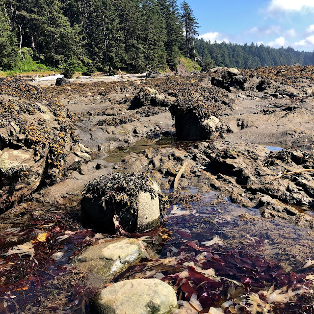
As a former phycology geek, I marveled at all the Pacific Ocean algae that I remembered from my Southampton College classes with Dr. Larry Little - reds, and greens, and leathery brown kelps, fucus, white, bone-like jania, and massive bulbous bull whip kelps. I crept across the rocky tidepools and poked around their contents with childlike wonder.  

Bull Whip Kelp
A wide patch of foot-deep algae formed a band along the tideline.  It was rotting in the sun and man did it stink!


Peering down the coast, I was reminded of the miles ahead of me and I reluctantly made my way to the pebbly beach.
Tearing my gaze away from the beach, the slope leading down to the beach had its own special charm.
Snapping pictures as I slowly moved south...
The algae Fucus drapes all the intertidal rocks.
Here's one of my favorite images from the whole trip!
Or if you prefer Black and White...

Some of the sections of the beach were littered with a wide band of timber.  If collecting beach wood, this is your mecca.  You just have to carry it out 4-5 miles!
I  made way slowly, as one does walking in the sand.  While I made 3 mi/hr on the way to the beach, I estimated 1 mile/hr to account for exploration and the slower pace of beach walking.  I was casually looking for ancient petroglyphs and climbed the beach slopes where trails led up into the cliffs.  I didn’t find any and tramped on snapping photos as I went.  As time wore on, and without distinct mile markers or landmarks on my park service map, I felt a sense of urgency to make it to Sand Point, where the trail would leave the beach and turn for home.

Tucked up near a rock outcropping, I spied this marker that looked purposefully placed, but because there was no sign or anything, I thought it was maybe some flotsam that had just been nailed up.
 
An offshore pinnacle....
 Bulbous kelp...

Beach pinnacles.  I searched for petroglyphs along the way but did not find any.  Next time, I will spend a whole day at Ozette looking for these historic wonders.
Looking back northward...

Nearing the 3 mile mark, I found this dead and decaying sea lion.  Tragic, but kinda cool too.


On the offshore rocks, I could see a single seal or sea lion hauled out.  It was too far to tell which.

Looking back northward from whence I'd come.
Looking south again, I spied a landform that fit the description of Sandy Point so I picked up the pace.  Making the point, I found people milling about - a clear sign of the campsites.  I walked around the point and the former rocky coastline changed dramatically to a wide, sandy beached embayment.  I great place for a swim if you can stand the cold (and sharks I presume!). 

 I asked one camper, and she directed me to the trail back to the ranger station.
 Before heading back, I was tempted to take one last look at the rocky Pacific Coast. Where the spur trail popped out on the beach, I found this sign and had an epiphany.
 
Checking the legend on the Park Service map, it stated that these markers were placed to mark overland trails to use when the tide was high and the beach was flooded.  This red one identified the location to pick up the trail back to the ranger station.

 After eating a little PB to fuel the 3.2 miles home, I bid farewell to the Pacific and ducked into the forest once more.
 The trail back to the Ranger Station was on rickety, weak, and broken boardwalk.  Staying on the underlying stringers, avoiding the broken boards, and skipping over the missing ones occupied my thoughts as the miles ticked away.  I was thinking how unconscionable it was to have the boardwalk in such a precarious condition, but reminded myself of how the Park Service maintenance projects were woefully under-funded, and how I had bristled at the $35 park entry fee.  In retrospect, for what it offered, it was worth every penny and then some!

The ubiquitious banana slug!
 I hustled to the car, threw all the gear in, had a long draw on the water bladder spigot, uploaded some photos to Instagram and then wheeled my chariot back down the dirt road. 

I made it to the Breakwater Restaurant, between Sekiu and Clallam Bay, just as the sun was setting over the Strait of Juan de Fuca.
I grabbed a window seat to watch the show.  My waitress was in no hurry and more interested in socializing so I watched the sun go down and sipped a cold can of Silver City Scotch ale poured into a plastic cup for $5 extra.  
 I finished my meal, took the last sip, and snapped a quick pick of the sunset afterglow.
 My rating to the Breakwater Restaurant? The food was mediocre, the service was horrendous but the location was great.  I climbed back into the rental and lurched through the dark.  Like a trusted horse, my Hyundai made it back to the Sol Duc campground, I brushed my teeth, crawled into the Big Agnes and sleep took me quickly.